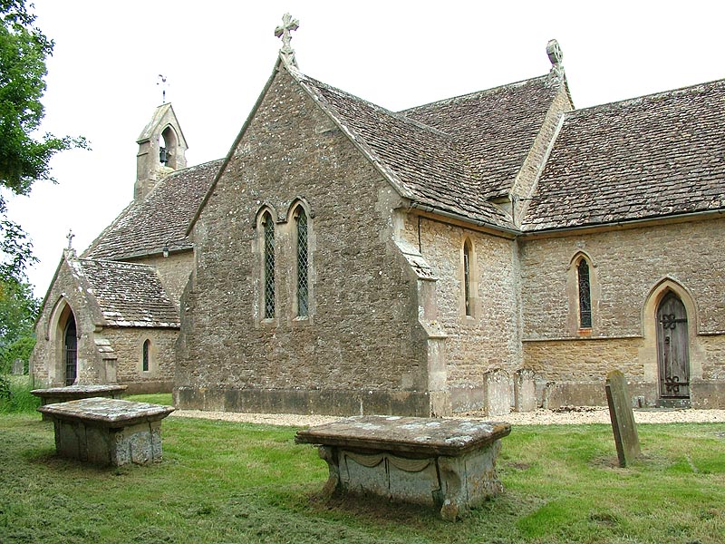
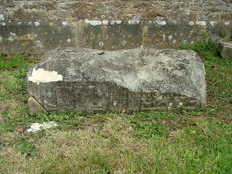
The village of Seagry lies five miles south east of Malmesbury and six miles north east of Chippenham, within Malmesbury Hundred. It is composed of two hamlets: Upper Seagry (first noted in 1317 as 'Over Seagry') lies to the west of the Sutton Benger-Great Somerford road; Lower Seagry (first noted in 1218 as 'Nether Seagry') has grown up on the lower ground around the Church. The ancient parish of Seagry was bounded in the east by the Bristol Avon and adjoined Christian Malford parish; in the west it was bounded by a tributary of the Avon and adjoined Stanton St. Quintin and Sutton Benger parishes. The northern boundary to the triangular-shaped parish adjoined that of Great Somerford. In 1934 the parish of Seagry was included within that of Sutton Benger. The modern parish of Seagry was formed in 1971; covering 1,468 acres it includes land lying to the north of the M4 motorway that had previously been included within the parishes of Draycot Cerne and Sutton Benger.
The north-south road from Great Somerford to Sutton Benger runs through the centre of the parish; this road was turnpiked in 1809 and disturnpiked in 1876. At the point at which it passes between Upper Seagry and Lower Seagry another road branches westwards from it towards Stanton St.
Quintin. At Upper Seagry this east-west road is itself intersected by another road running from Malmesbury to join the Great Somerford to Sutton Benger road in the south of the parish.
The name 'Seagry' itself has been interpreted as deriving from the Old English for 'sedge stream' and may have referred to the condition of the Avon. The land on which Seagry sits is Oxford Clay, (Kellaways Clay) with Kellaways Sand outcrop; deposits of alluvium and valley gravel lie near the Avon and alongside a tributary of the Avon to the west. The land is almost flat, the highest point in the parish, Seagry Hill, being only 73 metres above sea level, and the lowest, by the Avon, approximately 50 metres.
Prehistoric activity around Seagry has been indicated by the discovery, in 1985, of an Upper Palaeolithic artefact in the east of the parish.
F
u
r
t
h
e
r
m
o
r
e
,
n
o
t
e
s
i
n
<
e
m
>
W
i
l
t
s
h
i
r
e
A
r
c
h
a
e
o
l
o
g
i
c
a
l
M
a
g
a
z
i
n
e
<
/
e
m
>
o
f
1
9
5
0
a
l
l
u
d
e
t
o
a
t
r
a
d
i
t
i
o
n
,
n
o
t
e
d
i
n
t
h
e
l
a
t
e
n
i
n
e
t
e
e
n
t
h
c
e
n
t
u
r
y
a
n
d
t
r
a
c
e
d
b
a
c
k
t
o
t
h
e
e
i
g
h
t
e
e
n
t
h
c
e
n
t
u
r
y
,
t
h
a
t
e
v
i
d
e
n
c
e
o
f
b
u
r
i
a
l
s
s
u
g
g
e
s
t
e
d
t
o
b
e
o
f
t
h
e
l
a
t
e
B
r
o
n
z
e
A
g
e
w
e
r
e
f
o
u
n
d
i
n
t
w
o
f
i
e
l
d
s
i
n
U
p
p
e
r
S
e
a
g
r
y
.
&
n
b
s
p
;
H
o
w
e
v
e
r
,
e
v
i
d
e
n
c
e
o
f
s
u
c
h
f
i
n
d
s
d
o
e
s
n
o
t
n
o
w
e
x
i
s
t
a
n
d
t
h
e
r
e
f
o
r
e
t
h
e
t
h
e
o
r
y
c
a
n
n
o
t
b
e
c
o
n
f
i
r
m
e
d
.
<
/
p
>
<
p
>
&
n
b
s
p
;
<
/
p
>
<
p
>
I
n
1
9
7
9
a
h
a
n
g
i
n
g
b
o
w
l
e
s
c
u
t
c
h
e
o
n
o
f
t
h
e
S
a
x
o
n
p
e
r
i
o
d
w
a
s
d
r
e
d
g
e
d
u
p
f
r
o
m
t
h
e
A
v
o
n
a
t
S
e
a
g
r
y
.
&
n
b
s
p
;
T
h
e
d
a
t
i
n
g
a
n
d
p
r
o
v
e
n
a
n
c
e
o
f
s
u
c
h
b
o
w
l
s
h
a
v
e
b
e
e
n
t
h
e
s
u
b
j
e
c
t
o
f
d
i
s
p
u
t
e
w
h
i
c
h
h
a
s
c
o
n
s
i
d
e
r
e
d
t
h
e
m
t
o
b
e
e
i
t
h
e
r
o
f
l
o
c
a
l
B
r
i
t
i
s
h
p
r
o
d
u
c
t
i
o
n
,
o
r
i
m
p
o
r
t
e
d
f
r
o
m
I
r
e
l
a
n
d
,
o
r
t
h
e
p
r
o
d
u
c
t
i
o
n
o
f
I
r
i
s
h
m
o
n
a
s
t
i
c
f
o
u
n
d
a
t
i
o
n
s
i
n
E
n
g
l
a
n
d
.
&
n
b
s
p
;
C
e
r
t
a
i
n
l
y
t
h
e
h
y
b
r
i
d
C
e
l
t
o
-
S
a
x
o
n
s
t
y
l
e
h
a
s
b
e
e
n
c
o
n
s
i
d
e
r
e
d
t
o
r
e
s
u
l
t
f
r
o
m
I
r
i
s
h
i
n
f
l
u
e
n
c
e
.
&
n
b
s
p
;
&
n
b
s
p
;
T
h
e
d
a
t
e
o
f
t
h
e
S
e
a
g
r
y
e
s
c
u
t
c
h
e
o
n
h
a
s
b
e
e
n
p
o
s
t
u
l
a
t
e
d
a
s
t
h
e
s
e
c
o
n
d
h
a
l
f
o
f
t
h
e
s
e
v
e
n
t
h
c
e
n
t
u
r
y
a
n
d
t
h
e
&
n
b
s
p
;
p
o
s
s
i
b
l
e
r
e
l
e
v
a
n
t
s
i
g
n
i
f
i
c
a
n
c
e
o
f
t
h
e
f
o
u
n
d
i
n
g
o
f
t
h
e
m
o
n
a
s
t
e
r
y
a
t
M
a
l
m
e
s
b
u
r
y
b
y
a
n
I
r
i
s
h
m
a
n
,
M
a
e
l
d
u
b
h
(
6
0
0
-
6
5
0
A
D
)
n
o
t
e
d
.
<
/
p
>
<
p
>
&
n
b
s
p
;
<
/
p
>
<
p
>
I
n
1
0
8
6
t
h
e
r
e
w
e
r
e
t
w
o
m
a
n
o
r
s
w
i
t
h
i
n
t
h
e
p
a
r
i
s
h
:
Durand of Gloucester was overlord of one manor ('Segrete'). His land was held by two knights and, before the Conquest, had been held by two thegns. The land comprised five hides and four ploughs (carucates), of which one hide and one plough were in demesne. There were also forty acres of meadow and a population of twenty to thirty people. The overlordship of this manor was passed through succession to Humphrey de Bohun, created Earl of Hereford in 1200. In the thirteenth century land held by Alice Cockerell in the manor was conveyed by her and by her daughters Felice and Isabel with their husbands, William Chambers and Alexander of Broom respectively, to Bradenstoke Priory. In 1373 the Priory held the entire manor and continued to do so until Dissolution.
At Domesday the overlord of a second manor ('Segrie') was Dru Fitz Ponz . This manor had been held before the Conquest by Wiflet, who paid geld for five hides of land. In addition to the five hides, Domesday notes four ploughs, two mills and thirty acres of meadow. The demesne holdings comprised two hides and one plough. Population of this manor is estimated as between sixty and ninety. Through succession the manor was held in the 12th century by Walter Ponz, who married the heiress of Clifford Castle and whose son, also Walter, adopted the name Walter de Clifford. De Clifford founded the church of St.
Mary the Virgin in 1172, and his effigy remains there today.
The manor continued to be held by members of the Drew family in the fourteenth and fifteenth centuries. After the manor was allotted to Isabel Mompesson, a daughter and coheir of Thomas Drew who had held the manor between 1428-1451, it was transmitted by succession through to Sir Richard Norton who sold it in portions in 1648 and died in 1652. Rebecca Stratton purchased the largest portion, Lower Seagry Manor, which was inherited after her death in 1678 by Ann Stratton, the widow of Rebecca's son Thomas. Stratton Farm, later known as Church Farm, continued to be held by members of the Stratton family until the mid-eighteenth century when it passed into the hands of the Fox, Barons Holland, family until the mid-nineteenth century. It was sold in 1864 to Henry Wellesley, Earl Cowley, and subsequently changed ownership through sales in 1920, 1947 and 1958.
In the course of their history both manors acquired land in all parts of the parish. However, the two hamlets of Upper Seagry and Lower Seagry remained distinct: Upper Seagry concentrated at and near the junction of the north-south Malmesbury road and the road to Stanton St.
Quintin, the settlement of Lower Seagry remaining focussed around the church.
Within the two hamlets a number of important houses and farms have existed: The manor house of Lower Seagry may have stood on the site of Church Farm, close to the Church. Its tithe barn, with a large archway leading through it, dates from the 15th century. To the north of the Church stood, in 1761, Jacobs Farm which in the early 19th century was replaced by a pair of cottages later converted into one dwelling. A little further north stood Piott's Farm, which burned down in 1927 and was replaced in approximately the following year by a large house known as Lower Farm. Part of the Seagry House estate, Lower Farm passed through a succession of ownerships including from 1939 to 1984, Trinity College Cambridge and from 1940 onwards was known as Trinity Farm. On the west side of the Malmesbury road in Upper Seagry stands Seales Court, formerly Seales Farm. On the east side of the road are Manor Farms and the property known as the Chestnuts. Ten council houses were built in approximately 1950 in the area west of the Malmesbury road and south of the Stanton St.
Q
u
i
n
t
i
n
r
o
a
d
.
<
/
p
>
<
p
>
&
n
b
s
p
;
<
/
p
>
<
p
>
S
e
a
g
r
y
H
o
u
s
e
,
s
t
a
n
d
i
n
g
o
u
t
s
i
d
e
t
h
e
t
w
o
h
a
m
l
e
t
s
,
w
a
s
b
u
i
l
t
b
y
N
a
t
h
a
n
i
e
l
H
o
u
l
t
o
n
i
n
a
p
p
r
o
x
i
m
a
t
e
l
y
1
7
4
0
a
n
d
t
h
e
S
e
a
g
r
y
H
o
u
s
e
e
s
t
a
t
e
w
a
s
s
o
l
d
i
n
1
7
8
5
t
o
S
i
r
J
a
m
e
s
T
y
l
n
e
y
-
L
o
n
g
.
&
n
b
s
p
;
T
h
r
o
u
g
h
s
u
c
c
e
s
s
i
o
n
i
t
p
a
s
s
e
d
t
o
t
h
e
e
a
r
l
d
o
m
o
f
C
o
w
l
e
y
.
&
n
b
s
p
;
I
n
1
9
2
0
L
o
r
d
C
o
w
l
e
y
s
o
l
d
m
o
s
t
o
f
t
h
e
l
a
n
d
t
o
W
i
l
t
s
h
i
r
e
C
o
u
n
t
y
C
o
u
n
c
i
l
.
&
n
b
s
p
;
S
e
a
g
r
y
H
o
u
s
e
i
t
s
e
l
f
r
e
m
a
i
n
e
d
i
n
t
h
e
o
w
n
e
r
s
h
i
p
o
f
t
h
e
C
o
w
l
e
y
f
a
m
i
l
y
u
n
t
i
l
1
9
4
9
,
o
c
c
u
p
i
e
d
a
t
t
h
a
t
t
i
m
e
b
y
C
l
a
r
e
,
w
i
d
o
w
o
f
H
e
n
r
y
E
a
r
l
C
o
w
l
e
y
w
h
o
h
a
d
d
i
e
d
i
n
1
9
1
9
.
&
n
b
s
p
;
T
h
e
h
o
u
s
e
w
a
s
l
a
r
g
e
l
y
d
e
s
t
r
o
y
e
d
b
y
f
i
r
e
i
n
1
9
4
9
.
&
n
b
s
p
;
&
n
b
s
p
;
The 1377 poll tax assessments indicate that the two hamlets of Upper Seagry and Lower Seagry had 45 and 64 poll tax payers respectively. It is suggested that supporting the population of the parish in the Middle Ages may have been open fields held by each of Upper and Lower Seagry, with a common meadow, known in 1207 as Seagry Meadow. In 1585 the parish had North, East and West fields and, by 1648 Down field in addition.
Taxation assessments of the 16th and 17th centuries indicate that Seagry was among the poorest parishes in the Malmesbury Hundred.
All open fields had been enclosed by 1720 but the water meadow lands known as Lower Mead and Hungerford Mead lying beside the River Avon and totalling 124 acres remained open until 1883. The value of water meadows to agricultural production has been well documented and included the provision of early feed to livestock and a greatly increased yield of hay. Their decline in the late nineteenth century was due to causes which included not only the agricultural slump in this period, but the introduction of artifical fertilisers, improved grass strains, other sources of early feed and the cost of the skilled labour required for the maintenance of the water channelling structures of the meadows.
Of the two mills lying within the manor held by Dru Fitz Pons, one had fallen into disuse by 1207.
The remaining mill was, in 1648, in operation as a water mill and fulling mill for woollen cloth and was part of Lower Seagry manor. It is known that an inhabitant of Seagry bought wool in Gloucestershire to sell speculatively. It is also known that Joseph Houlton who bought land in Seagry from 1710 was a Trowbridge clothier and Robert Hollis, living at the Chestnuts in 1761 was a woolstapler. At this time the mill was part of Church Farm and remained so until 1864 when it was sold to James Godwin. It continued in Godwin family ownership until by 1910 it was part of the Seagry House estate. It was sold off by Lord Cowley in 1920 and finally demolished in 1950.
The church of St.
Mary the Virgin dates from 1172. In 1182 Alexander of Seagry made a gift of the church to Bradenstoke Priory whose priors continued to appoint vicars until the Dissolution. The rectory estate and advowson were sold to Richard Oakham in 1560. They were subsequently held by Sir John Danvers and his wife Elizabeth from 1572-1612 and then by Henry, Baron Danvers, created Earl of Danby in 1626. Having been settled on Danvers' regicide brother Sir John Danvers and his wife Elizabeth in 1628, the rectory estate was forfeited to the Crown in 1661 and subsequently passed to Sir John's trustees and his son Henry. In the eighteenth century it was acquired by Robert Earl, created Earl of Carnarvon in 1793. The estate and advowson remained with the earldom until 1927.
The church itself had gained its name of the Church of St. Mary the Virgin by 1763. It had a chancel and nave with a south chapel, south porch and west belltower. It underwent alterations in the fourteenth century and was completely rebuilt at a cost of £860 in 1849 to the plans of John Henry Hakewill. The sum of £860 had been raised from a number of sources: £100 from a parish rate; £200 for the chancel from the patron, the Earl of Carnarvon and £100 for the south transept from Lord Holland. The remainder was raised by public subscription.
T
h
e
r
e
b
u
i
l
d
i
n
g
b
e
g
a
n
o
n
7
<
s
u
p
>
t
h
<
/
s
u
p
>
J
u
n
e
1
8
4
9
a
n
d
t
h
e
c
h
u
r
c
h
w
a
s
r
e
o
p
e
n
e
d
o
n
8
<
s
u
p
>
t
h
<
/
s
u
p
>
N
o
v
e
m
b
e
r
o
f
t
h
e
s
a
m
e
y
e
a
r
.
&
n
b
s
p
;
T
h
e
f
o
n
t
,
r
o
o
d
s
c
r
e
e
n
,
t
w
o
e
f
f
i
g
i
e
s
,
m
e
m
o
r
i
a
l
t
a
b
l
e
s
,
b
e
l
l
a
n
d
s
o
m
e
f
l
o
o
r
t
i
l
e
s
w
e
r
e
r
e
t
a
i
n
e
d
f
r
o
m
t
h
e
o
r
i
g
i
n
a
l
c
h
u
r
c
h
,
t
h
e
b
e
l
l
b
e
i
n
g
r
e
c
a
s
t
i
n
1
8
4
9
.
&
n
b
s
p
;
<
/
p
>
<
p
>
&
n
b
s
p
;
<
/
p
>
<
p
>
S
t
a
i
n
e
d
g
l
a
s
s
i
n
t
h
e
t
w
o
l
a
n
c
e
t
w
i
n
d
o
w
s
o
f
t
h
e
s
o
u
t
h
p
o
r
c
h
w
a
s
g
i
v
e
n
b
y
H
a
k
e
w
i
l
l
.
&
n
b
s
p
;
T
h
e
o
r
g
a
n
w
a
s
b
u
i
l
t
i
n
1
8
8
8
a
n
d
a
c
q
u
i
r
e
d
i
n
1
8
9
1
.
&
n
b
s
p
;
M
e
m
o
r
i
a
l
t
a
b
l
e
t
s
i
n
t
h
e
c
h
u
r
c
h
i
n
c
l
u
d
e
o
n
e
d
e
d
i
c
a
t
e
d
t
o
R
e
b
e
c
c
a
S
t
r
a
t
t
o
n
a
n
d
o
n
e
t
o
h
e
r
s
o
n
R
o
b
e
r
t
.
&
n
b
s
p
;
T
h
e
e
f
f
i
g
y
o
f
t
h
e
c
h
u
r
c
h
'
s
f
o
u
n
d
e
r
,
W
a
l
t
e
r
d
e
C
l
i
f
f
o
r
d
,
l
i
e
s
i
n
t
h
e
s
o
u
t
h
t
r
a
n
s
e
p
t
a
n
d
t
h
a
t
o
f
I
s
a
b
e
l
l
M
o
m
p
e
s
s
o
n
,
i
n
t
h
e
c
h
a
n
c
e
l
.
<
/
p
>
<
p
>
&
n
b
s
p
;
<
/
p
>
<
p
>
T
h
e
r
e
w
a
s
a
l
s
o
a
n
o
n
-
c
o
n
f
o
r
m
i
s
t
p
r
e
s
e
n
c
e
i
n
S
e
a
g
r
y
.
&
n
b
s
p
;
A
P
r
i
m
i
t
i
v
e
M
e
t
h
o
d
i
s
t
c
h
a
p
e
l
w
a
s
b
u
i
l
t
i
n
U
p
p
e
r
S
e
a
g
r
y
i
n
1
8
2
5
a
n
d
r
e
m
a
i
n
s
i
n
u
s
e
t
o
d
a
y
a
s
S
e
a
g
r
y
M
e
t
h
o
d
i
s
t
C
h
u
c
h
.
&
n
b
s
p
;
I
n
a
d
d
i
t
i
o
n
,
Q
u
a
k
e
r
b
a
p
t
i
s
m
s
a
n
d
m
a
r
r
i
a
g
e
s
w
e
r
e
r
e
c
o
r
d
e
d
i
n
t
h
e
l
a
t
e
1
7
<
s
u
p
>
t
h
<
/
s
u
p
>
a
n
d
e
a
r
l
y
1
8
<
s
u
p
>
t
h
<
/
s
u
p
>
c
e
n
t
u
r
i
e
s
i
n
v
o
l
v
i
n
g
t
h
e
K
e
r
f
o
o
t
e
,
W
h
e
e
l
e
r
a
n
d
A
d
y
f
a
m
i
l
i
e
s
.
<
/
p
>
<
p
>
&
n
b
s
p
;
<
/
p
>
<
p
>
A
n
u
n
p
l
e
a
s
a
n
t
c
r
i
m
e
o
c
c
u
r
r
e
d
w
i
t
h
i
n
t
h
e
p
a
r
i
s
h
i
n
N
o
v
e
m
b
e
r
1
8
2
0
w
h
e
n
a
n
e
l
d
e
r
l
y
w
o
m
a
n
,
J
u
d
i
t
h
P
e
a
r
c
e
,
w
a
s
m
u
r
d
e
r
e
d
i
n
t
h
e
g
r
o
u
n
d
s
o
f
h
e
r
c
o
t
t
a
g
e
a
t
t
h
e
f
o
o
t
o
f
S
e
a
g
r
y
H
i
l
l
.
&
n
b
s
p
;
C
o
n
v
i
c
t
e
d
o
f
h
e
r
k
i
l
l
i
n
g
a
t
t
h
e
S
a
l
i
s
b
u
r
y
L
e
n
t
A
s
s
i
z
e
s
i
n
1
8
2
1
,
a
g
y
p
s
y
n
a
m
e
d
E
d
w
a
r
d
B
u
c
k
l
a
n
d
w
h
o
h
a
d
b
e
e
n
i
n
t
h
e
a
r
e
a
f
o
r
a
b
o
u
t
t
w
e
n
t
y
y
e
a
r
s
,
c
a
r
r
y
i
n
g
o
u
t
o
d
d
j
o
b
s
a
n
d
b
e
g
g
i
n
g
,
w
a
s
s
h
o
r
t
l
y
a
f
t
e
r
w
a
r
d
s
e
x
e
c
u
t
e
d
i
n
D
e
v
i
z
e
s
M
a
r
k
e
t
P
l
a
c
e
.
&
n
b
s
p
;
L
o
c
a
l
m
y
t
h
s
a
n
d
f
o
l
k
l
o
r
e
,
b
o
t
h
i
n
S
e
a
g
r
y
a
n
d
S
u
t
t
o
n
B
e
n
g
e
r
,
r
e
f
e
r
r
e
d
t
o
h
a
u
n
t
i
n
g
s
b
y
B
uckland and resulted in children's "dares" to approach the victim’s cottage.
At the beginning of the nineteenth century agriculture was mainly pastoral; grain was grown on 67 acres and root crops for fodder on 29 acres. In 1840 the acreage given to arable farming on the five farms in Upper Seagry and three in Lower Seagry had increased to 137 acres; however, the number of acres given over to pasture was 886. The size of the farms was not large, the smallest being 33 acres and only one exceeding 200 acres. After approximately 1886 there was a steady decrease in the amount of arable until only 36 acres were ploughed in 1933. Between 1916 and 1933 no sheep were kept and holdings were limited to cattle and pigs. Of these an average of 280 cows and 76 pigs were kept between 1876 and 1933.
Wages rates for agricultural labourers in Wiltshire and Dorset were low in comparison with other areas. Travelling through Wiltshire on his "rural rides" in 1825 William Cobbett had written that he had never seen finer countryside nor had he ever witnessed labouring people who were more miserable. Wages remained low even after the upheavals of the Swing Riots. A study of population in Seagry in the nineteenth century suggests that it was not immune to the influence of factors affecting rural communities more widely both in the county and nationally, particularly in terms of mobility and migration.
Migration might initially be local, within the county. Notably, the towns of Chippenham and Calne increased significantly in population over the course of the nineteenth century, the former through the development of the engineering industry with a rise in population from 3,366 in 1801 to 12,677 in 1901; the latter’s population rose from 3,767 in 1801 to 5,518 in 1819, partly due to the operations of the Harris bacon factory. Migration from Wiltshire to the growing ports of Bristol and Southampton also took place and may have been another option taken up by those leaving Seagry. Migrants generally were likely to be in the 15-35 years age group and large numbers of young women, particularly those living in close proximity to a railway, travelled to London to find employment as domestic servants.
In Seagry the average household size declined between the censuses of 1851 and 1891, which indicated fewer three generation households. The percentage of dependant children (to fifteen years of age) however remained fairly consistent, though with a dip in 1871. In these years the numbers of agricultural labourers declined; in 1831 most men in the village had been agricultural labourers, in 1851 there were forty-four and in 1891 there were nineteen. This trend was in keeping with a wider national decline.
O
v
e
r
a
l
l
p
o
p
u
l
a
t
i
o
n
i
n
t
h
e
t
w
o
h
a
m
l
e
t
s
d
e
c
r
e
a
s
e
d
b
y
a
t
h
i
r
d
b
e
t
w
e
e
n
1
8
7
1
a
n
d
1
8
8
1
a
l
t
h
o
u
g
h
n
o
s
i
m
i
l
a
r
d
e
c
r
e
a
s
e
i
s
a
p
p
a
r
e
n
t
i
n
t
h
e
p
o
p
u
l
a
t
i
o
n
s
o
f
G
r
e
a
t
S
o
m
e
r
f
o
r
d
a
n
d
L
i
t
t
l
e
S
o
m
e
r
f
o
r
d
.
&
n
b
s
p
;
H
o
w
e
v
e
r
,
i
n
c
r
e
a
s
e
d
m
o
b
i
l
i
t
y
a
m
o
n
g
s
t
t
h
e
p
o
p
u
l
a
t
i
o
n
i
n
g
e
n
e
r
a
l
a
l
s
o
l
e
d
t
o
s
o
m
e
i
n
-
m
i
g
r
a
t
i
o
n
a
n
d
t
h
e
f
o
l
l
o
w
i
n
g
d
e
c
a
d
e
1
8
8
1
-
1
8
9
1
s
a
w
a
r
i
s
e
i
n
S
e
a
g
r
y
'
s
p
o
p
u
l
a
t
i
o
n
o
n
c
e
a
g
a
i
n
.
<
/
p
>
<
p
>
&
n
b
s
p
;
<
/
p
>
<
p
>
A
m
a
j
o
r
f
a
c
t
o
r
i
n
p
o
p
u
l
a
t
i
o
n
s
t
r
u
c
t
u
r
e
a
n
d
a
c
c
e
s
s
t
o
a
g
r
i
c
u
l
t
u
r
a
l
m
a
r
k
e
t
s
i
n
t
h
e
l
a
t
e
n
i
n
e
t
e
e
n
t
h
c
e
n
t
u
r
y
w
a
s
t
h
e
c
o
m
i
n
g
o
f
t
h
e
G
r
e
a
t
W
e
s
t
e
r
n
R
a
i
l
way generally and the establishment of a station in 1877 at Great Somerford, only one and a half miles distant, specifically. The effects of the post-1870 agricultural depression included those on arable farmers competing with cheap grain imports from America, Canada and Australiia, on meat producers also as a result of imports, and in particular on dairy farming which was hit by a series of wet, cold summers and falls in prices of cheese due to American imports. Consequently there was a move to liquid milk production amongst farmers within reach of railways by which their product could be easily transported to urban centres. The decline in acreage given over to arable farming in Seagry in the nineteenth century may indicate that it too was influenced by such new marketing possibilities.
New opportunities for employment arose within the railway companies themselves, and also from the development of Swindon as a major focus of the Great Western Railway with its associated engineering works.
Although in the twentieth century Seagry remained a small community, in the early years it enjoyed a number of commercial services: a trade directory of 1911 lists in addition to a number of farmers a market gardener, coal and corn dealers, baker, grocer, post office, beer retailer, auctioneer and estate agent, and cattle dealer. However, by 1935 only the post office, grocer and beer retailer remained in operation.
In June 1949 a letter of appreciation with a cheque for £65 raised from subscriptions was presented to the post-mistress who, in addition to the general business of the post office, had operated a manual telephone exchange on a 24 hours a day basis from its installation in 1914 until the imminent changeover to an automatic system.
The year 1971 brought another major change to Seagry's circumstances in terms of transport developments and resulting possibilities for mobility and access to markets. In this year the section of the M4 motorway which passed within approximately one mile of Seagry was constructed and cut through the countryside between the village and Sutton Benger. The road to the latter was carried over the motorway by means of a bridge, but in the 1974 reorganisation of local authorities the two parishes were again separated for administrative purposes.
The fact that the motorway not only passed so closely to Seagry but also brought with it junction 17 only a few miles away meant that population structure and employment opportunities were again open to major changes, not least through greatly enhanced possibilities for commuting. Nevertheless, the publication of a book to record Seagry's activities and residents at the start of the new Millenium in 2000 indicated a continuing cohesion within the two hamlets.